Showing posts with label Hurricane. Show all posts

Monday, September 10, 2012

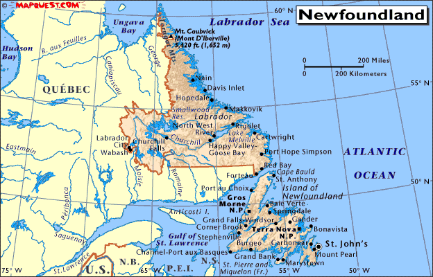
Impact of TS Leslie on Newfoundland & Labrador

This Atlantic Hurricane Season continues to surprise as Tropical Storm Warnings have been issued along the coasts of Newfoundland. It is not that uncommon but we would like to analyze it impact on the region over the next 24 hours. 

  • Canadian Province: Newfoundland and Labrador
    • Population: 500,000+
  • Primary City Impacted:  St. John's, Newfoundland
    • Population: Metro: 196,000+
  • Tropical Storm Leslie
    • Maximum Wind Speeds: 70mph
    • Wind Gusts: 85mph
    • Movement: NNE at 31mph


The rapid rise of elevation should help reduce inland flooding. Tropical Storm Leslie will move past rapidly and looks maintain its intensity over the next 36 hours. The speed to the storm will lead to minimal residence time over the island. The precipitation map from Hamweather.net states that 24-hour precip will vary from 1-5 inches across the island. Leslie will make landfall this morning and will then travel to Iceland as a 60mph tropical storm.  


Friday, September 7, 2012

September 7: Forecast Update for Hurricane Leslie

     As most of you have heard by now, the tropical system named Leslie has been churning in the Atlantic for over a week. She has been slow-moving, only moving a couple hundred of miles northward since Monday morning. We will be taking a look at what is in store for the future of this system.

Infrared image of Leslie at 7:45 EDT September 8 courtesy of CIMSS

     As of 2 PM AST, Leslie was downgraded to tropical storm status by the National Hurricane Center, with sustained winds at 65 mph. Leslie has been struggling with organization over the past week. Vertical wind shear aloft over the last few days has been preventing strong convective development. Now, slow propagation northward due to little or no steering currents has caused upwelling of cold waters; this has lead to the weakening of the system in the past 24 hours.


     Over the next 36 hours, Leslie should move northward over waters with ample warmth allowing it to restrengthen in an environment with little vertical shear. The latest runs of the GFS, ECMWF, HWRF, and GFDL models have all suggested that the storm will reach wind speeds of up to 92 mph in that time, insisting category 2 strength. The extensive mid-level trough currently moving eastward across the United States will accelerate the steering winds south of Leslie, pushing it north-northeastward. 

ECMWF model output graphics courtesy of WeatherBELL Models
     As of now, models are having the storm sparing Bermuda from direct impact, passing just east of the island. As it moves northeast into higher latitudes at an increasing rate, cooler waters and wind shear will weaken Leslie considerably. Models 96 hours out then suggest an interaction with Hurricane Michael, illustrated by the 12Z run of the ECMWF model (pictured left). This interaction would lead Leslie to deflect into a more northerly path. This northerly track would put Leslie in line for landfall in Newfoundland, impacting cities such as St. John's and Saint-Pierre. The 18Z model ensemble on the tracking of Leslie is noted below. The majority of the models are hinting landfall near St. John's, Newfoundland.

http://derecho.math.uwm.edu/models/al122012.png
Model ensembles courtesy of http://derecho.math.uwm.edu/models/

     For us at Stratustatus, Leslie is forecast to become a weak category 2 hurricane before being carried away by the southerly flow of the incoming mid-level trough. The system will weaken gradually as it moves northeastward past Bermuda into the higher midlatitudes. Michael, which will likely be a tropical storm, will interact with Leslie, causing Leslie to take a northern trajectory towards the eastern portion of Newfoundland. Leslie will potentially make landfall near St. John's, likely as a tropical storm by Wednesday, September 12th. This forecast will be updated when necessary.


Monday, September 3, 2012

The Tough Times of Forecasting Isaac


          Tropical storm Isaac was the first hurricane to make direct U.S. landfall this year. It was a storm of unusual timing and confusion, which led to the extreme amount of media coverage over the past week.

TS Isaac managed to delay the RNC
          The timing of this system could not have been worse. Earlier this week Isaac managed to postpone the Republican National Convention in Tampa, Florida, while school systems in Southern Florida cancelled their Monday classes. Once all of this mitigation was in place Isaac ironically managed to spare much of the Eastern coastline of Florida minus the Keys.

           Much chaos surrounded the actual projected path of Isaac as it made its way into the Caribbean. Weather computer models had anything from the storm brushing up against the Atlantic coast to making direct landfall in Louisiana. The path of Isaac was directly correlated with the speed and strength of a high pressure ridge, which was predicted to make its way across the United States. Three different weather models (complex equations that predict future conditions of the atmosphere) pushed out different results. The Canadian Model predicted that this ridge of high pressure would drive Isaac on a more eastern path into the Atlantic Ocean. The European Weather Modeling system believed that the ridge would dissipate causing Isaac to break into the middle of the Gulf of Mexico. The United States weather model, known as the GFS, predicted a path that would directly impact Florida. These models helped generate the cone of uncertainty of the system.
Wx Models had Isaac making landfall anywhere from New York to Louisiana
         The Weather-computing model that ended up winning out was the European Model, which has supposedly been the most accurate at tropical forecasting in the recent years. The next difficult task, which meteorologists faced, was predicting the intensity of the storm. The storm initially was to be at hurricane strength shortly after passing through the Florida Keys. The initial hypothesis suggested that Isaac would be a strong category 2 hurricane at landfall. In order for it to be classified a category 2 storm the winds must be between 96-110 miles per hour, which brings with it storm surge of 6 -8 feet. Over time, it became evident that the storm was battling dry air entrainment (dry air entering a moist system) and wind shear (Different direction or speeds of winds at different levels of the atmosphere, which can cause weak cloud structure). Both of these factors often inhibit intensification of a tropical system.

           Wind speed slowly intensified while the storm rapidly dropped in pressure. Pressure of the storm is loosely correlated with a tropical system’s wind speed. As Tropical Storm Isaac slowly inched his way to landfall the pressure dropped to a typical category 2 hurricane, which puzzled many meteorologists. Isaac broke a North Atlantic record for having the lowest pressure level ever recorded in a Tropical Storm. There was much disagreement among meteorologists as to when it should have been dubbed a hurricane. The National Hurricane Center felt that the classification system should be a cut and dry yes or no decision. Others felt that there were winds somewhere in the system at hurricane strength and that hurricane status should have been issued early Tuesday morning to urge lingering residents to evacuate low-lying locations of Southeastern Louisiana. 
          Early Tuesday afternoon Tropical Storm Isaac upgraded his status and a hurricane was born. The system’s strongest winds topped out at 80 miles per hour as it slammed the Louisiana, Mississippi, and Alabama coastlines. The hurricane managed to generate enough surge to top 8 foot levees, which left many residents on their rooftops awaiting rescue. New Orleans had rainfall totals that topped 20 inches. Others storm totals can be seen here: http://www.nola.com/hurricane/index.ssf/2012/08/isaacs_rainfall_totals_through.html

ABC News
          The storm has now transitioned into a Tropical Depression as it moves into the Midwest just in time for Labor Day weekend. Locations of Indiana, Ohio, and Illinois should expect a rainfall total ranging from 1-5 inches over the next few days. CNN Money has already released an article stating that the destruction caused by Isaac could hit 2 Billion dollars in damage. See here: http://money.cnn.com/2012/08/31/news/economy/isaac-damages/

          Even though Hurricane Isaac is no more, individuals should be wary for the continuation of activity in the Atlantic Ocean. The months of September and October are generally the most active of Hurricane season. The ocean waters are warmest in the Atlantic and Gulf of Mexico during this time year. 
Monday, July 16, 2012

Ingredients for Hurricane Development


People can compare hurricane development to daily cooking instructions. A hurricane requires several ingredients to make the storm strong. If you take away or reduce some of the ingredients the hurricane will begin to weaken or lack the flavor of its true recipe.
The first and most possibly most important ingredient in hurricane development is water temperature. Hurricanes are considered warm-core systems, which means they require warm moisture to function and operate. The temperature threshold for tropical development is 80 F at the waters surface. The warm water increases the evaporation rate of the surface water. This in turn generates water vapor and cloud development.  Along with very warm surface temps there needs to be a deep layer of warm water to continuously feed the storm. In late summer, Water temperatures within the Gulf of Mexico and Caribbean reach these temps rather quickly due to the shallow ocean depth.
The next ingredient in hurricane development is the storm’s accessibility to moisture at all levels of the atmosphere. If the storm were to come into contact with a pocket of dry air the system will significantly begin to weaken in intensity.
A hurricane develops vertically as well as horizontally across a region of the Ocean. This can produce a system that covers large area. The high cloud development can be hindered if there is too much vertical shear at the hurricanes location. Shear is the change in direction of wind at different heights within the atmosphere. If there is too much shear the clouds at the top of the storm can blow away, which ultimately destroys the system.
The next thing to set a hurricane in motion is the creation of spin or rotation of the cloud and thunderstorms. The phenomena called Coriolis Effect is created by the spinning motion of the earth. The closer the storm is to the equator the weaker the rotation in the atmosphere, which can destroy the storm.
The last ingredient to the hurricane recipe is the collection of thunderstorms that flow off the coast of Africa into the Atlantic Ocean. These westward moving storms ,if strong enough, can be considered a tropical wave. As the thunderstorms and showers move across the ocean they can strengthen into stronger tropical disturbances but often times weaken and dissipate out at sea.
These required ingredients are needed to make or break a powerful Hurricane. Warm water, moisture, little shear, rotation, and tropical waves each play a important part in the storms cycle.